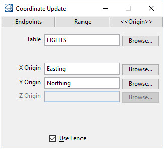
Coordinate Update

The Coordinate Update dialog provides to tools for extracting the endpoints, range or origin from selected features and updating the corresponding database rows. The elements must have existing database linkages.
| Setting | Description |
|---|---|
| Endpoints | Extracts the beginning and ending endpoints of linear elements and adds the resulting values to the specified columns. |
| X Begin, X End | The columns specified for storing the beginning and ending X coordinate when the Endpoint option is used. |
| Y Begin, Y End | The columns specified for storing the beginning and ending Y coordinate when the Endpoint option is used. |
| Z Begin, Z End | (3D only) The columns specified for storing the beginning and ending Z coordinate when the Endpoint option is used. |
| Range | Extracts the X, Y and Z coordinates of the element range and adds the resulting values to the specified columns. |
| X Low, X High | The columns specified for storing the low and high X coordinates when the Range option is used. |
| Y Low, Y High | The columns specified for storing the low and high Y coordinates when the Range option is used. |
| Z Low, Z High | (3D only) The columns specified for storing the low and high Z coordinates when the Range option is used. |
| Origin | Extracts the origin coordinates of point features and adds the resulting values to the specified columns. |
| X Origin | The column specified for storing the X coordinate when the Origin option is used. |
| Y Origin | The column specified for storing the Y coordinate when the Origin option is used. |
| Z Origin | (3D only) The column specified for storing the Z coordinate when the Origin option is used. |
| Table | The feature table containing columns that will be populated with coordinates extracted by the Endpoints, Range and Origin options. |
| Use Fence | Specifies that the selected command (Endpoints, Range, Origin) should operate on elements within a fence. |